


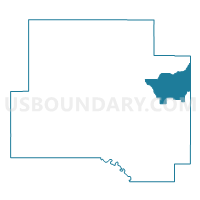
Voting District 11, Johnston County, Oklahoma
About
Outline

Summary
| Unique Area Identifier | 654171 |
| Name | Voting District 11 |
| County | Johnston County |
| State | Oklahoma |
| Area (square miles) | 26.97 |
| Land Area (square miles) | 26.65 |
| Water Area (square miles) | 0.32 |
| % of Land Area | 98.83 |
| % of Water Area | 1.17 |
| Latitude of the Internal Point | 34.36079660 |
| Longtitude of the Internal Point | -96.45691520 |
Maps


Graphs
Select a template below for downloading or customizing gragh for Voting District 11, Johnston County, Oklahoma


Neighbors
Neighoring Voting District (by Name) Neighboring Voting District on the Map
- Voting District 10, Johnston County, OK
- Voting District 12, Johnston County, OK
- Voting District 13, Johnston County, OK
- Voting District 6, Atoka County, OK
Top 10 Neighboring County Subdivision (by Population) Neighboring County Subdivision on the Map
Top 10 Neighboring Place (by Population) Neighboring Place on the Map
Top 10 Neighboring Unified School District (by Population) Neighboring Unified School District on the Map
- Coalgate Public Schools, OK (4,518)
- Milburn Public Schools, OK (1,301)
- Wapanucka Public Schools, OK (1,253)
- Coleman Public Schools, OK (993)